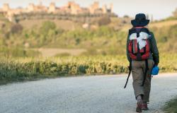
The moment when I fully realized that I was actually walking from Bologna to Florence - 130 km on foot -, I was hiking up the steep slopes of Mount Adone, in the Bologna Apennines; I looked to the right and saw, down in the valley below, the Autostrada del Sole, the highway that connects the two cities. Reaching Florence from Bologna on the autostrada takes about an hour – on foot, it would take me six days. I was on my second day, the climb was strenuous, my right knee was hurting, but I was determined.
This was going to be my first long-distance trek: roughly 130 kilometers (81 miles) through the Apennine mountains, which form the natural border between the regions of Emilia Romagna and Tuscany, walking on trails alternating between magnificent forests and panoramic ridges with beautiful views over valleys and mountains. For me, a native of Bologna, it would also be a way to get to know more deeply, more slowly, the area near my home; don't we too often overlook places close to home without realizing how beautiful and special those places can be?

[Large meadows covered with colorful flowers are a common sight during Spring in the Apennines. Photo by Silvia Donati.]
The History Behind the 'Via degli Dei'
The walking route connecting Bologna with Florence is known as ‘Via degli Dei’ – the Path of Gods. Why the intriguing name? The man credited with devising the route grew up in the valleys and mountains south of Bologna (it would perhaps be more appropriate to say he ‘rediscovered’ the route - more on that later); the story goes that, as a child, riding in the car with his father, he kept seeing a road sign with the words “Via degli Dei”; he fantasized about this road, wondering where it would lead, intrigued by such a mysterious and poetic name. The young boy grew up, but never forgot about ‘la via degli dei’ and, towards the end of the 1980s, he convinced a group of friends to help him find the trails that, from the outskirts of Bologna, lead to the Futa Pass in Tuscany, passing by the road he traveled on as a child. The trails touch on mountains named after gods and goddesses: Monte Adone (Adonis), Monzuno (Mons Junonis), Monte Venere (Venus) and Monte Luario (Lua). Hence the name Via degli Dei given to the road, hence the name chosen for the trek.

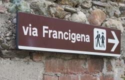
[The signs for the Via degli Dei are marked V.D. and feature two yellow balls. Photo by Silvia Donati.]
I have written that using the word ‘rediscover’ would be more appropriate because in reality the Via degli Dei is a very ancient path, traveled on foot since Roman, and possibly even Etruscan, times. In fact, the central stretch of the Via degli Dei coincides with the Roman road Flaminia militare, built in 187 BC to connect the important colony of Bononia (Bologna) with Arretium (Arezzo) in Tuscany. While the Flaminia Militare lost its military importance during the Middle Ages, and as a consequence was progressively covered with vegetation, it continued to be used, as a trail, by the numerous pilgrims and wayfarers, traders and bandits, who needed to make the crossing through the Apennines. In recent times, parts of the Flaminia Militare were patiently dug out, during the course of 20 years, by two local volunteers. It is quite a thrill when you suddenly find yourself deep in the woods walking on Roman ‘basolato’ (the type of road paving used by the ancient Romans), thinking that you are walking on the same trail our ancestors walked on 2,000 years ago.

[The Flaminia Militare, a Roman road dating to 187 BC, coincides in part with the Via degli Dei. Photo by Silvia Donati.]
The 'Via degli Dei' Itinerary
La Via degli Dei begins in Bologna’s main square, Piazza Maggiore , and ends in Florence’s world-famous Piazza della Singnoria, touching on many natural and historical points of interest.
On a beautiful sunny morning, I departed Bologna with my hiking partners. After the uphill climb along the Portico of San Luca, at 3.8 km the longest portico in the world, we reached the Sanctuary of the Madonna di San Luca, a symbol of Bologna. We then proceeded for a long stretch along the Reno river, mentioned by Dante in Canto XVIII of the Divine Comedy's Inferno, where he defines the Bolognesi as those “living between the Savena and the Reno”.
The Via degli Dei offers several occasions for detours to discover the rich history of the territories it traverses. One such occasion is the Guglielmo Marconi Museum in Pontecchio Marconi, housed in the former home of the Nobel prize winner who pioneered long-distance radio transmission and wireless telegraphy.
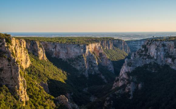
From a natural point of view, the highlight of the first stretch is the Contrafforte Pliocenico, a group of rocky sandstone cliffs dating to the Pliocene (between five and two million years ago), the result of the sedimentation of sand transported by the Apennine rivers and subsequent erosion caused by the wind and sea. Its bizarre rocky spurs are especially visible on the peak of Monte Adone, at 600 meters above sea level.

[Monte Adone, where the unique rock formations of the 'Contrafforte Pliocenico' are well visible. Photo by Silvia Donati.]
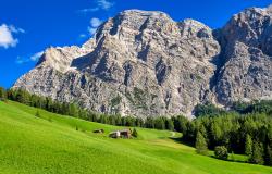
On the second stretch of the walk, we entered deep into the heart of the Apennines, traversing a changing landscape: vast green fields dotted with an explosion of colorful flowers, woods of beech, chestnut, conifer trees, high ridges providing panoramic views. By the end of the third day we were at the Futa Pass, once one of the most important passes of the Apennines, used to connect Bologna with Florence before the Autostrada del Sole was built. The Gothic Line, the defensive line built by German troops during World War II, passes by the Futa; the nearby German military cemetery, which, with 33,000 tombs, is the largest German cemetery in Italy, stands as a sober reminder of the atrocities of any war.
The landscape changed again when we emerged from the woods in the Mugello valley, which runs parallel to the Apennines along the river Sieve; there could be no doubt that we were in Tuscany, with its magnificent, elegant, soothing rolling hills, covered with olive and cypress trees, dotted here and there with tiny villages and gorgeous villas, such as the Medici Villas, magnificent rural buildings built by the Medici between the 15th and 17th centuries.

[The unmistakable Tuscan countryside, here near Fiesole and Florence. Photo by Silvia Donati.]
We reached the ancient town of Fiesole, founded by the Etruscans. Fiesole is worth a stop to see the ruins of the Etruscan walls, the Roman baths and theater, the Duomo, the 14th-century Town Hall. It is also worth a stop for a delicious pappa al pomodoro or any Tuscan specialty of your liking if you arrive, as we did, at lunch time.
We were ‘only’ 10 kilometers from our final destination. Florence was clearly visible, right below us. We could make out Brunelleschi’s dome.
 We left Fiesole by way of a delightful wood and then, finally, we emerged on a paved road, and we entered Florence. As we walked the relatively quiet streets of Florence’s outskirts toward the heart of the city, my excitement grew.
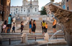
As we approached Piazza della Signoria, by then surrounded by the myriad tourists who always swarm the city, emotions were running high in the group. We entered the piazza with our arms up, big smiles on our faces, feeling elated, and a bit like pilgrims of the past.
[Our writer Silvia, happy at the end of the 135-km trek from Bologna to Florence.]
How to: The best times to walk La Via degli Dei are late Spring and early Fall. It is generally walked in five days. Modest hotels and agriturismi are available with short detours from the path. They provide bed sheets and towels so you don't have to carry them in your backpack. Water is available along the route, but start the day with at least 1.5 liter. More information can be found on La Via degli Dei website. A guidebook is essential if you're not doing the walk with an organized group.