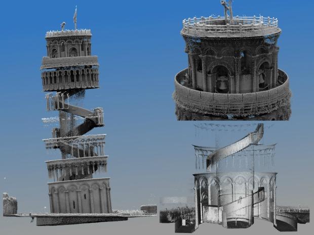
Italy’s iconic leaning Tower of Pisa has been mapped in 3D using a groundbreaking mobile laser technology.
The tower’s cramped stairs and complex architecture have prevented previous mapping technologies from capturing its interior. Now, the breakthrough Zebedee system has enabled researchers to create the first comprehensive 3D map of the whole building as part of the Project Pisa initiative. Developed by Australia’s national science agency, CSIRO, Zebedee is a handheld 3D mapping system. It incorporates a laser scanner that sways on a spring to capture millions of detailed measurements of a site as an operator walks through it. Software converts the data into a 3D map.
CSIRO collaborated with Italian scientists from Pisa’s Scuola Superiore Sant’Anna (Sant’Anna School of Advanced Studies) during Project Pisa. Italian scientists from the leading Italian research university believe the research will have a significant impact on preserving the tower’s cultural heritage.
Franco Tecchia, assistant professor at the Scuola Superiore Sant’Anna’s Perceptual Robotics lab, said: “Our detailed record of the leaning Tower of Pisa may one day be critical in being able to reconstruct the site if it was to suffer catastrophic damage due to natural disasters such as a fire or an earthquake. Having a detailed 3D model of the world’s most significant cultural heritage sites could also be used to allow people who cannot physically visit these sites to better understand and appreciate their history and architecture.”
Dr Jonathan Roberts, research programme leader at CSIRO’s Computational Informatics Division, said: “This technology is ideal for cultural heritage mapping, which is usually very time consuming and labour intensive. It can often take a whole research team a number of days or weeks to map a site with the accuracy and detail of what we can produce in a few hours.
“Within 20 minutes we were able to use Zebedee to complete an entire scan of the building’s interior. This allowed us to create a uniquely comprehensive and accurate 3D map of the tower’s structure and composition, including small details in the stairs and stonework.”
Watch Jonathan Roberts of CSIRO, part of the Australian national science agency, as he shows how the Zebedee scanner works.