By: Margherita Ragg
‘There used to be 25,000 people in my hometown, now there’s only 2500 of us left’ said Giuseppe, the taxi driver who picked us up in Piacenza and drove us to Bobbio, where the Via degli Abati starts. ‘We need more tourists’ he added.
In a world plagued by over tourism, it seems surreal to find places that are actively seeking tourists. Yet, if there ever were a place that fits the ‘off-the-beaten-path’ definition, the Apennines between the Parma and Piacenza provinces of Emilia Romagna would be it – a forgotten corner of Italy, not far from the busy Po Valley, but visited by far fewer people compared to the great ‘food cities’ that the region is famous for.
The Emilia-Romagna Apennines are the ideal destination to discover slowly, enjoying the peace and solace of nature, following ancient trails that once were the only way to move between towns and villages. The Via degli Abati, a 120 km trail between Bobbio and Pontremoli, is just one of many long-distance paths crossing these mountains, hoping to bring a new, respectful kind of tourism to places that desperately need revenue.
Bobbio and the Via degli Abati
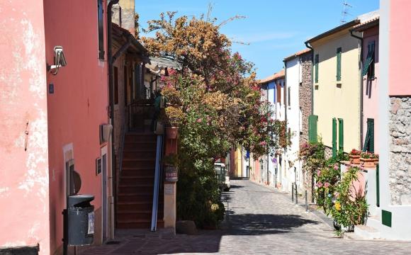
On a sweltering late June afternoon, Bobbio looked sleepier than ever. There was not a soul to be seen around the town’s sunny piazza and historic center – the only sound we heard was that of the River Trebbia, its crystal-clear waters flowing fast, and a faint breeze ruffling the leaves of the forests surrounding the town.
 [The pretty medieval city of Bobbio]
The history of Bobbio is linked to that of its Abbey, founded in the 7th century AD by Columban, an Irish monk who was given the land by the Lombard king. Bobbio became a very lively place, with monks traveling to and from the Abbey. After Columban’s death and canonization, devotees of the saint, traveling on foot from the British Isles all the way to Rome, often visited Bobbio, stopping enroute to see the places where the saint lived and prayed.
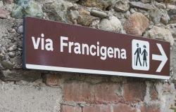
The mountain paths taken by monks and pilgrims were rediscovered in the 1990s by a local historian, and form part of the Via degli Abati, linking Bobbio to Pontremoli in Tuscany, where the trail meets the more famous Via Francigena to Rome. The Via degli Abati is in fact older than the Via Francigena –the latter was hiked for the first documented time in 990 AD, but there is evidence that the former was already in use three centuries earlier, at the time of Saint Columban.
 [Abbey of St. Colombano. Bobbio. Emilia-Romagna. Italy]
The Via degli Abati is often known as the Francigena’s ‘mountain variant’– a shorter but much harder alternative, ideal for those who want to avoid traffic and asphalt and are not afraid of long days and considerable altitude difference.
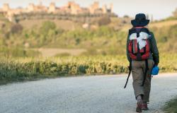
Hiking the Via degli Abati – What to Expect
The Via degli Abati starts at the Ponte Gobbo, a Medieval stone bridge across the River Trebbia, one of the many ‘devil’s bridges’ found across the Apennines of Tuscany and Emilia Romagna. The legend goes that a stonemason was given the task to build the bridge, but couldn’t find a way to do so, until the Devil appeared to him with a proposition – he would build the bridge overnight, in exchange for the first soul that would walk across it. The stonemason got a dog to walk across the bridge, saving the souls of the townspeople.
After crossing the bridge, it becomes immediately clear why the Via degli Abati is considered one of Italy’s most challenging long-distance hikes – it’s 6 constant uphill kilometers to Coli, the first village after Bobbio. The trail climbs nonstop, snaking its way in and out of a forest with no other soul in sight. Not far from Coli there’s a variant to reach the cave where Saint Columban lived the last few years of his life in solitude and prayer – this variant adds 4 kilometers to the trail, but it’s worth doing to explore a truly peaceful place immersed in nature.
At the end of the first day, after a seemingly never ending series of ups and downs, weaving in and out of timeless forests, the trail reaches the highest point – the Sella dei Generali, 1238 metres above sea level, a ridge where the pilgrim’s gaze travels across space and time, admiring wildflower-covered peaks and thinking of the many souls that braved these trails throughout history, when these mountains were full of dangers.
 [Sella dei Generali]
There are several possibilities to divide your journey along the Via degli Abati – after the first strenuous day, we stopped a B&B in Nicelli, run by Margret, a gregarious German lady who moved to the peace of the Apennines after a lifetime working in the fashion industry in Milan.
The first day, we hiked 21 km with 1400 meters altitude difference – in contrast, the second day felt almost like a relaxing walk, ‘only’ 14 kilometers with 700 meters uphill climb. The only challenging section is wading across the River Nure – otherwise, it’s a gentle, shaded walk all the way to Groppallo, a blink-and-you’ll-miss-it one street town.
 [Crossing the Nure river]
The following day, the trail continues uphill following a series of paths and mule tracks across the forest, passing abandoned villages and hamlets with only a handful of elderly residents. At Passo Linguadà, separating the Parma and Piacenza provinces, hikers can choose between continuing via the Monte Lama plateau, a flat-topped mountain where Paleolitic tools were found, or following the lower path running across the valley all the way to Bardi, a town famous for its imposing castle, dominating the town atop a red jasper rock.
 [Bardi's impressive fortress/castle]
Bardi was the town our driver Giuseppe was talking about, when he picked us up from Piacenza. In the late afternoon, it was crowded with families speaking English, French, German – the descendants of migrants who left en masse between the late 19thand early 20thcentury, looking for fortune abroad.
Many people have left, but some are slowly starting to return, attracted by the peace and wild nature of the Apennines. An example was Gino, a mushroom picking guide and B&B owner we met in Bardi, who switched nonchalantly between English with a soft Irish lilt and Italian with a heavy Parma accent. ‘I followed the same journey my grandparents did over a hundred years ago, but in reverse’he said ‘and I never looked back’.
On day 4, the Via degli Abati covers the stretch between Bardi and Borgotaro, the hardest of the whole trail, and the place where nature is at its wildest. The trail crosses streams, forests and orchards, abandoned villages and ruined farmhouses – in the village of Osacca, at the end of a spectacular beech forest, locals welcome pilgrims with a smile and a cool drink, following a tradition of hospitality unchanged for centuries.
 [Hiking in the forest of Emilia-Romagna]
The Via degli Abati continues following the Via Francigena for some time, until it reaches one of the remotest and most spectacular locations of the entire hike – a tiny, immaculate chapel called La Maestà, and offering shelter from the cold and bad weather. The entire trail is maintained by volunteers, each in charge of a specific section – but the identity of the person that keeps the chapel clean, changes the flowers on the altar and sweeps the floor is a mystery. Perhaps one of the ‘trail angels’, found along many of the world’s great hikes?
 [Il passo Linguadà]
Our experience along the Via degli Abati ended in Borgotaro, a town that felt like a metropolis after days of silence and forests. The railway crossing the valley brought a rush of disenchantment, the feeling of another adventure coming to an end.
Yet, the trail carries on – across the mountains and through over another valley to Pontremoli, and further on to Rome, following the footsteps of so many that crossed these mountains throughout the centuries, bound for the Eternal City.
Via degli Abati Practical Info
We recommend planning to hike the Via degli Abati between April/May and October, for the best chance of good weather conditions. However, please be aware that it’s likely to be very hot in June/July/August – make sure you have plenty of water and avoid hiking in the hottest part of the day.
It’s very easy to get to and from the Via degli Abati by public transport. Bobbio is serviced by a bus, with hourly departures from Piacenza’s railway station, while Pontremoli and Borgotaro are both on the Parma-La Spezia railway line.
If you have your own car, we recommend leaving it in Piacenza where there are several parking options near the station, and catching the bus to Bobbio, since it’s much easier to make your way back to Piacenza at the end of the hike than to Bobbio.
All along the trail there are several accommodation options including hotels, agriturismi, apartments and B&B, often offering discounts to people hiking the Via degli Abati. Check this site to download a list of places to stay. Many of these places also offer meals, otherwise there are places to eat in all towns at the end of each stage.
We recommend purchasing the official Via degli Abati paper map (for sale in Bobbio at the tourism office) and/or having a GPS or smartphone (with the ViewRanger app) loaded with the gpx track – you can download it here for free.