
With this article, ITALY Magazine begins a new series called “Walking Italy”. The series focuses on places in Italy best explored on foot, from gorgeous mountain tracks to countryside trails to pedestrian-friendly cities and neighborhoods. Walking allows you to slow down and savor things, something we can all benefit from, not to mention that it’s environmental-friendly. So, get walking!
As the focus of a visit to Italy is often art cities and charming countryside, perhaps not many visitors are aware that the country also features beautiful mountains offering plenty of opportunities to hiking lovers. Contributing editor Silvia Donati, a keen hiker herself, selects five of the top spots to release your hiking fever.
DOLOMITES' ALTA VIA, SOUTH TYROL
Nothing beats the Dolomites when it comes to hiking in Italy. This mountain range in the northern Italian Alps comprises 18 peaks rising above 3,000 meters. A UNESCO World Heritage site, which describes it as “some of the most beautiful mountain landscapes anywhere, with vertical walls, sheer cliffs and a high density of narrow, deep and long valleys,” it offers hiking opportunities for everyone, from leisurely one-day walks for the entire family on flat terrain to more challenging multi-day treks with significant elevation changes for experienced hikers. Among the most famous and coveted hiking trails in the Dolomites is the Alta Via 1 (High Route 1), a 150-kilometer high-level trail traversing some of the finest scenery in the eastern Dolomites. The path runs south from Braies Lake (Pragser Wildsee) to Belluno. You can expect to walk an average of seven hours a day completing the trail in 10-15 days. The Alta Via should be hiked between the end of June and September when the route is normally free of snow. There are rifugi (mountain huts) along the route for overnight sleeping (camping is forbidden). You can find a number of other high-level routes in the Dolomites, including the Alta Via 2.

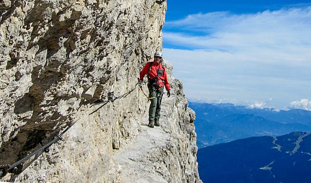
DOLOMITES' VIA FERRATA, TRENTINO
The southern neighbor of South Tyrol, which together form the region of Trentino-Alto Adige, Trentino is a mountainous area encompassing part of the Dolomites. The Marmolada, the highest mountain of the Dolomites, the Brenta Group, the Sella Group (a popular half day hiking tour is the Sass Pordoi to Piz Boé, the highest peak of the Sella mountain range at 3,152 meters, traversing moon-like landscapes) and the Pale di San Martino are some of the most famous mountain ranges here offering great hiking opportunities. The Brenta Group, sometimes called the Western Dolomites, within the park of Adamello Brenta, include eight peaks higher than 3,000 meters, and feature several via ferrata routes, the most famous being the Via delle Bocchette. The via ferrata, translated as “iron route”, is basically an access path to a mountain peak, usually on rocky slopes, equipped with cables, chains, pegs, and other fixed anchors such as ladders, walkways and ropes which facilitate the passage of hikers. Many of them are accessible to less experienced hikers, although they require good physical conditions, no fear of heights and lots of concentration. Many via ferrata were built during World War I to aid the movement of troops.
MONTE BIANCO AND MONTE ROSA, AOSTA VALLEY
Valle d’Aosta, located in the Western Alps in northwest Italy, bordering with France and Switzerland, is famous for its mountains, with steep peaks including Monte Bianco, Monte Cervino, Monte Rosa and Gran Paradiso. Monte Bianco (White Mountain) is the highest mountain in the Alps, rising at 4,810 meters. The Tour du Mont Blanc or TMB is considered one of the classic long-distance walks in Europe. It circles the Mont Blanc Massif covering a distance of approximately 170 kilometers, with 10 kilometers of ascent/descent, and passes through parts of Switzerland, Italy and France. It is usually walked in an anti-clockwise direction in 11 days, starting from Courmayeur if beginning on the Italian side. Should you want to move a little faster than at walking pace, you could always take part in the Ultra-Trail du Mont Blanc, an annual ultramarathon, which the top runners complete in 20 hours (!). The Monte Rosa Massif is the second highest mountain in the Alps, with peaks reaching more than 4,500 meters. The Monte Rosa Tour is a circular hiking trail around Monte Rosa consisting of nine legs with departure and arrival in Zermatt (Swiss side), traversing part of the paths once traveled by the native Walser people moving from one valley to the other. The name of mountain, which means ‘pink’, has nothing to do with the color, but rather derives from the Franco-Provencal Aostan word rouése, meaning ‘glacier’.

VALTELLINA, LOMBARDY
Often overshadowed by neighboring Trentino-Alto Adige and its famous Dolomites, Valtellina, a vast area extending for 200 kilometers within the northern region of Lombardy, right in the middle of the Alps, is absolutely beautiful. Park and natural reserves constitute more than a third of the Valtellina area, making it a paradise for hikers, who can find plenty of trails in the Stelvio National Park, the largest in Italy, covering part of Trentino Alto-Adige as well, and the Orobie Valtellinesi Park, with peaks between 2,000 and 3,000 meters. Famous hiking trails here include the Alta Via della Valmalenco, a 130-km journey dominated by the mountain peaks of Pizzo Scalino and Pizzo Bernina; the Gran via Delle Orobie, 130 kilometers traversing the Orobie Valtellinesi Park at an average height of 1,800 meters; the Sentiero della Pace (Peace Trail) in upper Valtellina, which crosses the battlefields of World War I; and the Via Alpina in Valtellina, an Alpine route crossing eight countries of the alpine chain: the Valtellina section goes from the 2,757-meter-high Stelvio Pass, the second highest in the Alps, to the Valchiavenna.

APPENNINO TOSCO-EMILIANO
Located on the border between Emilia-Romagna and Tuscany, neighboring regions separated by forest ridges, the Appennino Tosco-Emiliano includes the mountain area between the Cisa and Forbici passes and is dominated by the summits of Alpe di Succiso, Monte Prado and Monte Cusna (over 2,000 meters), lakes, and high-mountain grasslands. It is famous both for its beautiful natural landscapes and for the local high-quality food products and handicrafts. The unmistakable silhouette of Pietra di Bismantova, mentioned by Dante in his Divine Comedy, dominates the landscape with its vertical walls. You can follow the ridgeline of the mountains for kilometers on the ancient trails taken by merchants, pilgrims, bandits, and shepherds for centuries. The Monte Cimone is the highest mountain in the northern Apennines, with an elevation of 2,165 meters. The top of Mount Cimone is the geographic point from where you can see the widest Italian surface area: when visibility is good, in fact, you can see the Alps, the Adriatic Sea, Mount Amiata, the Argentario, the Tyrrhenian Sea, the island of Elba, Corsica and the island of Capraia. Not bad, right?